How long is the running of the bulls? The city of Pamplona gives the route as 848.6 meters, about 0.53 miles, and does not say how it was measured. The website sanfermin.com reports 875 meters, measured with a calibrated wheel in 2022. Mat Dowsett, a runner who paced the course around 2003, got 838 meters. The run itself usually lasts about three minutes.
Those are the numbers, and none of them is a typo. Each one starts and ends in a slightly different place, comes from a different year, or rests on a different method, yet most guides print one of them as settled fact. Dennis Clancey says it is funny that you ask, because there is no exact answer: the city publishes a number, that number gets updated, and some people measure the route themselves and claim another. The route also follows an imperfect path through old streets, which makes the question a loaded one.
Everyone asks about length, and length gets the attention. Width matters too, so this article gives it equal time, with the only on the ground measurements of it that we could find. Encierro founder Dennis Clancey has run the encierro since 2007, and he discussed how those measurements were taken with their author, Mat Dowsett, that same year. Every figure below is labeled by what stands behind it: stated by the city, measured with a stated method, or repeated from somewhere else.
Last updated 5 October 2026. Version 1.0.
How Long Is the Running of the Bulls Route? Every Published Number and Who Stands Behind It
Five figures circulate for the running of the bulls route. Three have a named owner, and two of those say how the figure was made.
| Figure | Who states it | When | Method stated | How to read it |
|---|---|---|---|---|
| 848.6 m | Ayuntamiento de Pamplona, on its route page and in press notes | 2022 to 2026 | None | The city’s own number. We could not find who measured it or when. |
| 875 m | sanfermin.com, a San Fermín information website | 2022 | Calibrated wheel odometer along the center of the street and plazas, from the Santo Domingo corral gate to the bull gate at the ring, after the Estafeta street reform and checked during the callejón works | The only wheel measurement we found. |
| 838 m | Mat Dowsett, runner and author | About 2003 | Paced on foot by the author, ending at the sand of the bullring | The oldest measured figure we found. |
| 850 m | Torrens Alzu, Pregón 56 | 2020 | None, a round figure | The city also says about 850 meters for the length of the fence, which is a different thing. |
| 825 m | Mallor and colleagues in Risk Analysis, citing the city’s website and sanfermin.com’s 2007 guide | 2007 to 2008 | None | An older figure, still found on Navarra’s regional tourism site in 2026. |
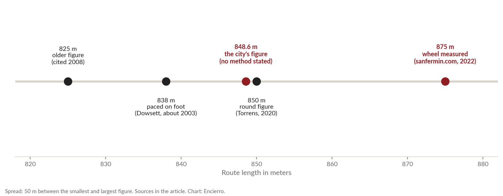
The spread is 50 meters, about 6 percent, or roughly half the length of an American football field. The table suggests why: the numbers measure different things. The wheel measurement runs from the Santo Domingo corral gate to the bull gate at the ring, along the center of the street. Dowsett ends on the sand of the bullring. The city does not say where its 848.6 meters starts or ends. Until the end points match, the figures cannot be compared like for like. That is our reading, not a finding, because no one has published the start and end points of the city’s number.
The older figures are older than they look. Dowsett reports that a 1992 book, Sanfermines: 204 Hours of Fiesta, gave 825 meters in one chapter and 848 in another, so both numbers were in print more than three decades ago. He also lists newspapers and authors who gave 800 meters, 900 yards, half a mile and even a mile, and concludes that every source gives a different figure.
We found no source that says the length of the route changed in meters over time. The shape of the course did change, and the history section below sets out how. But no one published before and after lengths, so a claim such as “the route used to be shorter” has nothing under it.
What We Could Not Find
- Who measured the city’s 848.6 meters, and when or how. We searched the city’s pages through 4 October 2026.
- Any width survey of the route by the city or a university.
- The width of the space between the two fences, and the height of the fence.
- Curb heights, and the paving material street by street.
How Long Does the Running of the Bulls Last?
The run starts at 8:00 a.m. and lasts about three minutes in a typical year. The figures come from four sources that do not all measure the same thing in the same way.
| Source | Figure | Note |
|---|---|---|
| Mallor and colleagues, Risk Analysis (2008) | About 3 minutes | Much longer if a bull separates from the herd |
| Dowsett (2003) | 2:30 to 4:40, average 3:23.75 | His own timing of the 2003 runs |
| sanfermin.com | Average 3:31 and median 3:00 over 271 runs from 1980 to 2012 | Source of the data not named. Averages of 3:58 in the 1980s and 2:58 in the 2010s. A goring adds about 60 seconds |
| EFE news agency, 31 May 2025 | Fastest herd 2:05 on 14 July 2015; fastest single bull 1:45 on 11 July 1997 | The 1997 bull ran ahead of the herd |
For a section by section breakdown of timing, see Encierro’s guide to how fast the encierro is.
What Streets Does the Route Follow, and How Long Is Each Section?
The route passes through the same places in the same order: the corral and Cuesta de Santo Domingo, the Plaza Consistorial in front of the Ayuntamiento, Calle Mercaderes, La Curva (the bend where Mercaderes turns into Estafeta, also called the Curva de Estafeta), Calle Estafeta, the Telefónica stretch, and the callejón into the Plaza de Toros. Encierro’s section by section guide to the route walks through each one.
| Section | The city’s length | Other figures | Notes |
|---|---|---|---|
| Corral and Cuesta de Santo Domingo | 280 m | None found | The city calls it steep and gives no percentage |
| Plaza Consistorial and Mercaderes | 100 m together | None found | Includes the bend into Estafeta |
| Estafeta | Not given | 300 m (Parisi et al., PNAS 2021); 315 m (Spanish Wikipedia); about 400 m (Dowsett) | The city describes a slight 2 percent slope. Sources conflict, and 400 m does not fit the totals (see below) |
| Telefónica | Barely 100 m | 90 m (two other sources) | The long left curve toward the ring |
| Callejón | Not given | 15 m (Dowsett); about 25 m (information sites) | The only fully enclosed part of the course, according to Dowsett |
The sections do not add up to any of the totals. Take the city’s 280, 100 and about 100 meters, add 300 for Estafeta and 15 to 25 for the callejón, and you reach 795 to 805 meters, which is 20 to 80 meters short of the five totals above. Use Dowsett’s 400 meters for Estafeta and you reach 895 to 905 meters, past every total. That points to different start and end points for each section, and to Dowsett’s 400 being the outlier. This is our arithmetic, not a finding.
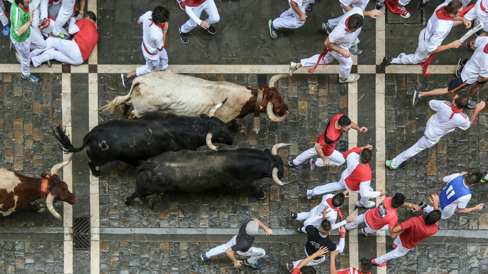
Dennis Clancey says two stretches feel longest to a runner. One is Calle Santo Domingo, a long hill that can take forever to run up and is very difficult. The other is Estafeta, the longest stretch of the route, fairly straight and slow to end. On Santo Domingo the problem is the animals as much as the hill:
“The bulls are disproportionately faster than humans while running uphill, and this is nowhere more obvious than at the beginning of Calle Santo Domingo.”
Dennis Clancey, Founder of Encierro
How Wide Is the Running of the Bulls Route? The Only Measured Widths We Found
Length is one number. Width changes every few meters, and it is harder to find. The city’s route pages give lengths and a slope but no widths, and we found no width survey by the city or a university. What exists is a set of measurements published in 2003 by Mat Dowsett in his book Encierro! A guide to the running of the bulls.
Who Is Mat Dowsett and How Did He Measure?
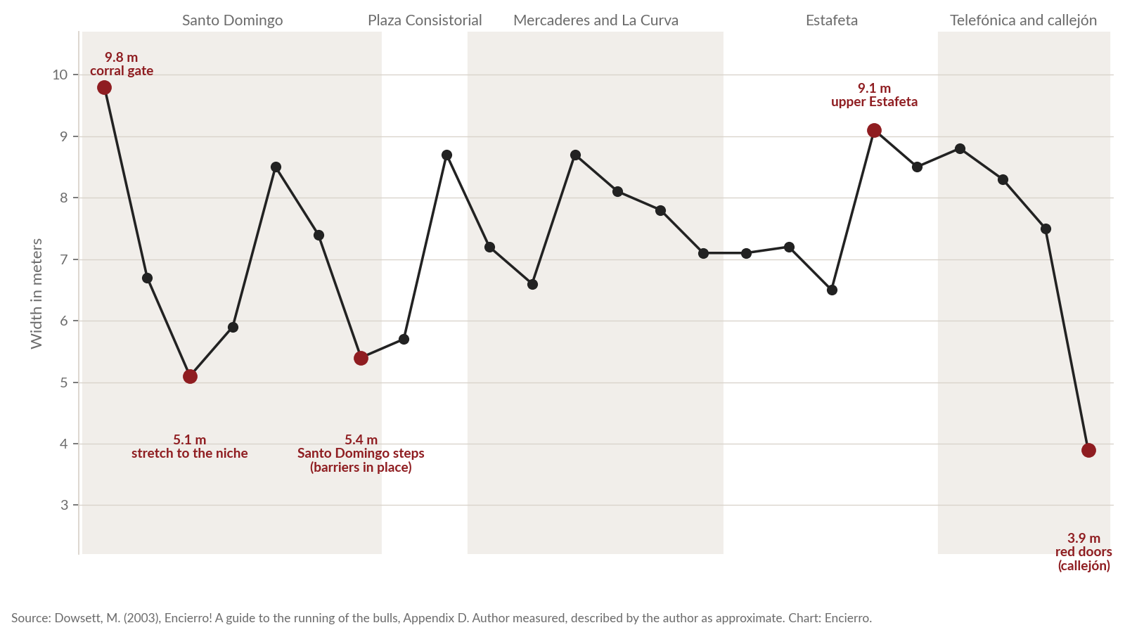
Dowsett is a British runner who first ran in 2001 and researched the route for his book, which was self published in 2003 and reprinted in 2004. An appendix on the dimensions of the course gives 24 width readings from the corral gate to the bullring doors, with a footnote: “Measurements are approximate but were carried out by the author!” The book does not name an instrument, a year or the exact points.
Dennis Clancey discussed the measurements with Mat in 2007, at a friend’s apartment on Calle Mercaderes. He says Mat measured with a tape measure, in Pamplona, to the building facades where facades limit the route and to the barrier where a barrier does. If that account is right, the figures are the clear width of the run as it stands on the day, not the width of the street. Mat is a friend of Dennis, and we say so because this article relies on his figures. We have not yet confirmed the method with Mat himself. The one thing we treat as certain is that he took the measurements in person and that they are his.
| Place, in route order (Dowsett’s description, shortened) | Width in meters |
|---|---|
| Where the bulls emerge from the corral at the bottom of Santo Domingo | 9.8 |
| Narrowing toward the high walls, by the stairs to the Museo de Navarra | 6.7 |
| The short stretch to the niche, which he calls one of the narrowest points on the course | 5.1 |
| Bottom of the ramp on the right of Santo Domingo, widening | 5.9 |
| After the slight turn near the shops on Santo Domingo | 8.5 |
| At the medical barrier just before the Town Hall | 7.4 |
| At the Santo Domingo steps, with barriers in place | 5.4 |
| Entrance to the Plaza Consistorial | 5.7 |
| Through the plaza turn to the start of Mercaderes | 8.7 |
| Mercaderes, where the buildings narrow the street | 7.2, then 6.6 where the buildings end |
| Diagonal barriers open the street before the drop to the curve | 8.7 |
| Start of the curve, across the diagonal, entrance to Estafeta | 8.1, 7.8, 7.1 |
| Estafeta lower section, first slight turn, higher up before it widens | 7.1, 7.2, 6.5 |
| Start of the wide upper part of Estafeta, very top of the street | 9.1, 8.5 |
| The long curve of the Telefónica stretch, then the top of the ramp down to the ring doors | 8.8, 8.3, 7.5 |
| The red doors of the bullring, the callejón, which he calls the narrowest section of the course | 3.9 |
Reading Dowsett’s Widths
The route is never uniform. It runs from 9.8 meters at the corral gate to 3.9 meters at the ring doors. After the callejón, the narrowest readings are on Santo Domingo: 5.1 meters in the stretch to the niche and 5.4 meters at the Santo Domingo steps with barriers in place. Estafeta, Dowsett warns, “is not as uniform as it appears”: 7.1 meters lower down, 6.5 meters higher up, then 9.1 and 8.5 meters at the top.
His own reading of the pattern is that extra width cannot guarantee safety. Narrow corridors look cramped, but they give the bulls a simpler and more obvious line to follow, while the wider sections give them more scope for turning and sidetracking. He also points to the funnel from the wide top of Estafeta, 9.1 meters, to the ring doors, 3.9 meters, and writes: “The greater the width the greater the degree of unpredictability.”
How Other Width Figures Compare
| Place | Dowsett (2003) | Other figure | Who, and method |
|---|---|---|---|
| Estafeta | 7.1 lower, 6.5 mid, 9.1 to 8.5 upper | Around 7 m | Parisi et al., PNAS 2021, who filmed the street from above in July 2019. No method for the width in the text we read |
| Mercaderes | 8.7 down to 6.6 | 9 m | Information websites, no method |
| Callejón | 3.9 | 3 m or 3.5 m | Information websites, no method |
| Between the two fences | Not given | 2 m | Two websites, no source. The city confirms a gap but gives no width |
Dowsett’s lower Estafeta readings of 7.1 and 7.2 meters match the PNAS “around 7 m”. The information sites’ 9 meters for Mercaderes is the top of his range, not a typical value. For the callejón, his 3.9 meters is the only measured value, and Dennis Clancey agrees it is the narrowest part of the route.
The Space Between the Fences
The city says the fence is a double wall with space between the two barriers, a refuge for runners and working space for medical staff, police and press. It publishes no width for that space. Two websites repeat “two meters” without a source, and Dowsett does not give it. We treat it as unmeasured. It also cannot be worked out from the street widths above, because the thickness of the fence is not published either.
What Width Means for a Runner
Dennis Clancey says width matters because it is the capacity of the route, the number of people it can hold in a given space. Capacity is not safety. In his words, “even where things are wider, it doesn’t mean that it’s safer.” On Estafeta, he says, the facades of the buildings are the limits of the route for most of its length, and there are very few places to leave it, the intersection at Bajada de Javier being one. When he briefs runners, he tells them that even where there is a barrier you think you could slip through, you cannot get off the route once the bulls are inbound, because the police will stop you leaving.
The same logic applies at La Curva. He says people standing on the inside assume the bulls will take a wide turn, but “there are so many people compacted in a small area” that those in it have “no freedom of maneuver to get out of a bad situation if the bull takes the turn tight.” In recent years, he says, the police have been removing runners from that area just before the bulls arrive. At the other end of the route, the problem is the funnel Dowsett measured:
“In the Bajada del Callejón, part of the challenge is that the route goes from its widest to its thinnest in a very short distance. Add to that the fact that you have runners who are running too early and moving too far up the run route, so the end of the run tends to be the most crowded. This creates more probability of people tripping each other and ending up in a montón.”
Dennis Clancey, Founder of Encierro
A montón is a heap of fallen people. Everyone asks how long the route is. The people standing in it care about how much room there is.
What Sets the Limits of the Route? Facades, Fences and Boarded Shops
On the day, the route is not a street. It is a corridor with walls: building facades where there is no fence, and a double wooden fence where there is. The widths above only make sense with that in mind, and so does what follows.
The Double Fence
The city’s 2024 note describes about 850 meters of double fence, 900 posts and 2,700 planks. Its notes give about 70 doors for 2018 to 2025 and 80 for 2026, and other sources give other counts. That 850 meters is the city’s figure for the fence, not a survey of the route. Assembly starts in the callejón and finishes around 6 July: 31 May in 2024, 2 June in 2023 and 2025, 1 June in 2026. Each morning from about 8:10, a large part of the fence is taken down so traffic can pass, and the city says the sections that affect traffic go up and come down daily. The firm Hermanos Aldaz Remiro, from Puente la Reina, has built the fence since 1992, hired through the Casa de Misericordia. Encierro’s map of the barrera gaps shows where runners can and cannot leave the route.
Shops, Doorways and Balconies
Under the city’s 2014 ordinance, premises with access from the route must be closed by 6:00, and doorways on the route must be shut from 7:30. The 2026 bando gives 7:15 for portals, a difference we could not reconcile. Keeping doors open after the closing times is prohibited, and so is standing in doorways or blind corners on the route.
Dennis Clancey says that wherever the facade of a shop forms part of the limit of the route, on any section, the shop is closed and boarded, and the shops fit the boards themselves, to protect the glass from collisions and from the bulls. We found no written rule or press report that describes this, so it stands as the observation of one runner of long standing. Dowsett’s book mentions a Town Hall deputation that walks the course at about 7:45 and can require that barriers be replaced or repaired, or that shops and houses be “better closed off.” Balcony condition, including the city’s 2026 inspection, is covered in Encierro’s guide to watching the running of the bulls in person.
How the Route Changed: From the Plaza del Castillo to the Callejón
Dennis Clancey says the physical route has not changed much: the path has not changed, and neither has the location of the fence. The documents show that the route was settled in stages, and that most of the change happened before 1922. The sources are Torrens Alzu’s history in Pregón 56 (2020) and Luis del Campo’s study of the bulls in Pamplona from 1800 to 1843, plus the city’s notes.
Before 1844: A Different Course
Between 1800 and 1843, del Campo writes from municipal archives, the bulls entered through the Portal de Rochapea, climbed the Cuesta de Santo Domingo, crossed the plaza and went along Mercaderes and up the Chapitela to the main door of a temporary wooden bullring on the Plaza del Castillo. Only blankets closed some openings and side streets. Torrens Alzu gives the same line and says the herd climbed the old ravine between the boroughs of San Cernin and Navarrería, crossed the Plaza Consistorial and entered Mercaderes. The two texts name the square differently, and neither settles whether the names are one square.
Several websites date the first wooden fence to 1776. We found no archive document for that date, and del Campo’s account of 1800 to 1843 describes blankets, not fences. How the running began is undocumented: no source we read dates the moment townspeople began to run with the herd rather than simply move it.
1844 to 1867: Short Runs, Protests and the First Bando
In 1844 the first fixed bullring opened inside the walls, in the orchard of the Carmelitas Descalzas, and it was demolished in 1849. A second ring opened for the 1852 fiestas. Runs of this period started at the Portal de San Nicolás and were short, and Torrens Alzu says nobody but the councillors liked them. After protests asking for a longer run, in 1856 the herd again left from the Santo Domingo corral, passed through Mercaderes and took Estafeta. From 1861 to 1867 the council’s decision prevailed and runs again started from San Nicolás.
In 1867 the first municipal bando on the encierro set the route from Santo Domingo to the bullring, with rules for runners and fencing. Torrens Alzu adds that the route was thereby fixed at about 850 meters, which he gives as his own summary, not as a quotation from the bando. We have not read the bando. Some sources say Estafeta has been used since 1867, which fits with 1856 as a first use and 1867 as the point from which it was continuous. We found no primary document for either date.
1867 to 1922: New Corrals, a Wider Corner and a New Ring
The city dates the use of the old gas works at the Rochapea as bull corrals to 1899, with permanent pens in 1918. The current Corralillos del Gas were built in 2003 according to the city, or 2004 according to Torrens Alzu.
The clearest change to the space of the route that we could date came in 1914. Torrens Alzu reports that the Casa Viscor block at the corner of Mercaderes and Calceteros was bought and demolished, opening a small plaza at that end of Mercaderes. Dowsett also dates the widening of Mercaderes to 1914 and says a block had almost separated Mercaderes from Estafeta before it.
The old ring burned in August 1921, and the new bullring opened with the encierro of 7 July 1922. The city says the new ring stood close to the old one largely to avoid changing the route, except for one curve, and Torrens Alzu says it definitively fixed the current route. The callejón was first used for the encierro on the morning of 7 July 1922.
1922 to 1976: Start Times, a Square and the Double Fence
The start moved from 6:00 to 7:00 in 1924 and to 8:00 in 1974. Dowsett’s chronology puts the construction of the Telefónica building, which gives that stretch its name, in 1926. Two sources that are not primary date a change to the layout of the plaza to 1931: Dowsett says the square was blocked off and kept as a square rather than a channel, and a history blog describes a transverse fence cutting the plaza to steer the bulls into Mercaderes. Dowsett adds that the curve from Mercaderes into Estafeta was much more square before.
In July 1939 a bull broke through the single wooden fence. The double fence followed in 1941 or 1942, depending on the source, and Dowsett’s own book gives the early 1940s in one chapter and the 1950s in another. We found no primary document for the decision.
1976 to 2013: Demolitions, Pedestrian Streets and Crowds
The Casa Seminario, a building that had narrowed Calle Santo Domingo, was demolished in 1979 according to Torrens Alzu, who says the area improved notably, or in 1976 according to another source. The city dates the niche of San Fermín in the wall at Santo Domingo to 1981. In an essay in Pregón 56, the photographer Pío Guerendiain argues that from the 1970s the mass of runners in Mercaderes stopped the herd from seeing the double fence at the Estafeta corner, so the animals no longer set their line to the opposite corner and slipped into it. It is one eyewitness account.
In the late 1990s the pavements on Estafeta and Mercaderes disappeared. Dowsett says they were replaced with a flat surface that slopes slightly to the center for drainage, and dates the end of the pavements to 1998. A history blog says Estafeta was pedestrianized in 1997. Neither is a primary source. The anti slip treatment of the surface began as a trial in 2005 and has been applied every year since 2006 except 2020 and 2021. On 13 July 2013 a large pile up at the entrance to the ring showed what a funnel does to a crowd.
2014 to 2026: Rules, Surface and Management
The 2014 ordinance set rules that include these: runners must be 18 or older, the run starts at 8:00, and from 7:30 only runners may remain on the route. In 2021 the city repaired the road and the slope wall on Santo Domingo, dug a new 186 meter drainage trench and rebuilt a section of sidewalk. In 2022, two news outlets reported, the red line at Santo Domingo was moved about 10 meters downhill after officials said it made the bulls hesitate, as if facing a wall.
In 2025 the Mesa del Encierro, the city’s consultative body, discussed putting smooth panels on the right side of the fence along the Telefónica and callejón stretch, so runners would not get trapped between boards, as elsewhere on the route. We did not find whether they were built. In 2026 runners could enter only through the Plaza Consistorial, no one could enter the route after 7:30, and runners who entered the bullring early were not allowed to stay on the sand. The city’s anti slip operation that year used about 1,500 liters over about 1,875 square meters, spread by hand with watering cans and brooms from 23:00 by a crew of about ten, from the end of the Santo Domingo slope through the Mercaderes curve and at the corral exit. The city gives the aim as better grip for the animals. No evaluation of its effect on falls or injuries has been published.
What a Runner Says Has Changed in His Years on the Route
Dennis Clancey lists four changes he has seen in his years of running, none of them to the path. Cable cameras over the route, on Estafeta and at the Ayuntamiento, are new. A treatment on the street to stop the bulls skidding has been added, which the city dates to a trial in 2005 and yearly use from 2006. The degree to which the cabestros, the steers that run with the bulls, are trained has changed. And the use of the swing doors at La Curva and further up Estafeta has changed over the years. The cameras and the doors do not alter the dimensions of the route, but they alter how it is run and watched.
He also recalls a decision, some years ago, to set the names of runners who died into the stones of the route where they were injured. According to the city, 16 memorial stones were planned and the first was set at Santo Domingo on 27 December 2023. Eight were installed, and in June 2024 the city removed them: its technical report found they were more slippery than the surrounding paving stones. Earlier, in April 2024, the Federación de Peñas had said the initiative was not agreed at the Mesa del Encierro, and the city postponed the debate pending a study of whether the plates posed a risk to runners in a fall. Dennis recalls the objection as a concern that the stones focused on the negative, rather than the celebration of life that San Fermín is meant to be. The sources give several reasons at different dates, and we do not print one as the cause.
A Cable Camera Over the Ayuntamiento, 2012
Dennis Clancey installed his own cable camera over the Ayuntamiento stretch of the route in 2012, for his film Chasing Red, which Magnolia Pictures distributed and which is available on Prime Video, Apple and other platforms. He needed special approval from the city’s Seguridad Ciudadana department, and it took months of planning and discussion. He says he was the first to install a camera over the route outside Estafeta and La Curva. Everything the camera saw fits the numbers above: a corridor whose width changes every few meters, filled in the last seconds before the bulls arrive.
What Nobody Has Measured Yet
Searching through 4 October 2026, we found no city or university survey of street widths, of the width between the fences, of fence height, plank size or post spacing, of curb heights, or of the paving material street by street. We also found no source for how the city arrived at 848.6 meters.
There are routes to some of these numbers. The Gobierno de Navarra’s mapping service (IDENA) and the cadastre hold building footprints from which a facade to facade width could be measured at fixed steps, though they do not show the fence. The San Fermín Crowd Lab, an agreement between the city and the University of Navarra that uses cameras and a LIDAR unit, may eventually publish width profiles. The fence builder and the Casa de Misericordia would hold the specification of the fence, and the city’s press office could say who measured 848.6 meters. We will update this article when any of them produces a figure, and the date at the top will change.
Frequently Asked Questions
How long is the running of the bulls in miles?
About half a mile. The city’s 848.6 meters is 0.53 miles, or 2,784 feet, the wheel measurement of 875 meters is 0.54 miles, and Dowsett’s paced 838 meters is 0.52 miles. We use the city’s figure as the headline because the city publishes it, and we label the others by who measured them. The run itself lasts about three minutes.
How long does the running of the bulls take?
About three minutes in a typical year. Dowsett timed the 2003 runs from 2:30 to 4:40, and sanfermin.com reports an average of 3:31 and a median of 3:00 over 271 runs between 1980 and 2012. The fastest herd on record, reported by EFE, took 2:05 in 2015. A bull that separates from the herd, or a goring, makes a run longer.
How wide are the streets on the running of the bulls route?
From 3.9 meters at the red doors of the bullring to 9.8 meters at the corral gate, according to the only on the ground measurements we found. They are Mat Dowsett’s, published in 2003 and described by him as approximate. Estafeta runs between 6.5 and 9.1 meters in his figures, and a 2021 research paper gives around 7 meters. The city has not published a width survey, and where a fence stands the clear width on the day can be narrower than the street.
What is the narrowest part of the running of the bulls route?
The callejón, the short passage into the bullring. Dowsett measured 3.9 meters at its red doors, and other websites say 3 or 3.5 meters without stating a method. Dennis Clancey agrees it is the narrowest part. The route funnels from about 9.1 meters at the top of Estafeta to 3.9 meters at the doors, and that is where runners pile up.
Has the running of the bulls route changed over time?
Yes, but not recently. Before 1844 the bulls finished at the Plaza del Castillo. Estafeta joined the route in 1856 according to Torrens Alzu, the first municipal bando of 1867 set the route from Santo Domingo to the bullring, and the new ring of 1922 fixed the current end. Since then the path and the position of the fence have changed little, according to Dennis Clancey, while the surface treatment, the rules and the cameras have changed.
Sources and Method
City of Pamplona: route page; press notes on the 2023 run, the 2024 fence, the 2026 fence and the 2026 anti slip treatment; the municipal ordinance; the 2026 traffic and access notice; the April 2024 note on the memorial stones and the note on their removal; the bullring centenary. Books and papers: Dowsett, M. (2003), Encierro! A guide to the running of the bulls, ISBN 0954635310; Torrens Alzu, Pregón 56 (2020); del Campo, Toros en Pamplona (1800 a 1843); Parisi et al. (2021), PNAS 118(50); Mallor et al. (2008), Risk Analysis 28(4).
Method: each figure is labeled by who states it and whether a method is given. Pages of the city were read through a text summary, so their wording is paraphrased here, not quoted. Dowsett’s widths were read from a text scan of the book and have not yet been checked against a printed page. Remarks attributed to Dennis Clancey are firsthand and are not confirmed by a written source unless stated. Version 1.0, 5 October 2026. Corrections are welcome and will be logged here.
Encierro founder Dennis Clancey has run the encierro since 2007. Every article on the Encierro blog is authored or reviewed by active bull runners with direct experience in Pamplona.